
 > Police >
POLICE Department
Crime Statistics for 12D30's Beat
Click on map for larger, more detailed image
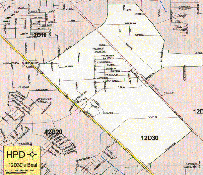
Beat Description and Boundary:
Beginning at the intersection of the Gulf Freeway and Alemda Genoa, the boundary goes east on Almeda Genoa until the Sreet divides at South Shaver. It continues east on South Shaver across Highway 3. South Shaver turns in a northerly direction. Almeda Genoa and shaver are the responsibility of 12D30. The boundary goes approximately 300 yards north of the intersection of South Shaver and Crenshaw. It then follows the city limits through an open field toward the east to Allen Genoa Road. The beat boundary continues to follow the city limits south on Allen Genoa to Mihovil Road. They turn east for about 100 yards, then south to Yepez, east on Yepez to Genoa Red Bluff. The city limits continue east on Genoa Red Bluff while the beat boundary follows Genoa Red Bluff south and west to Highway 3. Genoa Red Bluff is the responsibility of 12D30. It goes south on Highway 3 to Scarsdale. Highway 3 is the responsiblity of 12D40. It turns west on Scardale to the Gulf Freeway. Scarsdale is the responsibility of 12D30. It goes north on the Gulf Freeway to Almeda Genoa Road. The Gulf Freeway is the responsiblity of 12D30 from Sagedowne to Kingspoint. From Kingspoint to Almeda Genoa Road, the Gulf Freeway is the responsbility of 12D10. From Scardale to Sagedowne, the Gulf Freeway is the responsiblity of 12D40.
Landmarks and Neighborhoods Within This Beat:
Gulf Palms, Beamer
ZIP Codes Within This Beat (see note below on ZIP codes and beats):
77034
77089
77504