
 > Police >
POLICE Department
Crime Statistics for 10H70's Beat
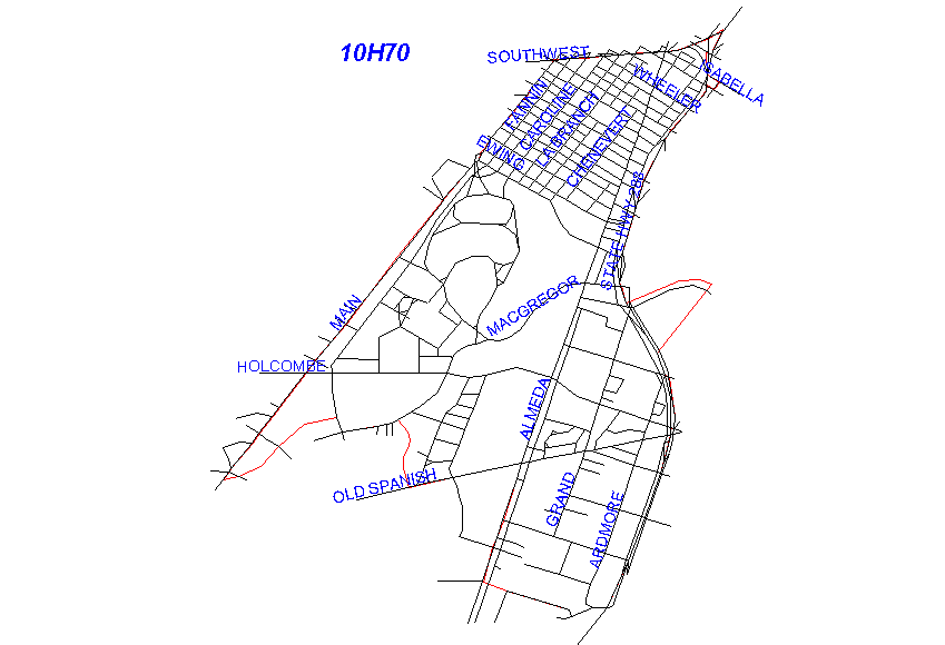
Click on map for larger, more detailed image
Beat Description and Boundary:
The boundary begins where the Southwest Freeway (I-59) crosses South Main and follows the Southwest Freeway east to the intersection with Highway 288. It turns south on Highway 288 and goes to the crossing of the Brays Bayou. It turns east along the Brays Bayou to where it is crossed by the HB&T railroad. The boundary turns south on the railroad to Highway 288 and continues south on Highway 288 to Holly Hall. Highway 288 from the Southwest Freeway to Old Spanish Trail is the responsibility of 10H70's beat. It takes Holly Hall west to El Camino. Holly Hall and El Camino are the responsibility of 15E40. At about the 2600 block of El Camino, it turns south and becomes El Rio. There is an open space to Almeda Road. On the west side of Almeda Road, there is another street called El Paseo. The boundary follows a straight lne from the end of El Camino to the intersection of Almeda Road and El Paseo. The boundary turns north on Almeda Road to Old Spanish Trail. Almeda Road is the responsibility of 10H70. At Old Spanish Trail, the boundary turns west to the west side of Brown Parking Lot of the Texas Medical Center. Old Spanish Trail is the responsibility of 10H70. It turns north along the west lot lines of Brown Parking of the Texas Medical Center and goes to South Braeswood. It turns east along the north side of Brays Bayou to the intersection with South Main. The boundary turns north on South Main and follows Main back to the Southwest Freeway, which is where it begins. South Main is the responsibility of 10H80's beat.
Landmarks and Neighborhoods Within This Beat:
Texas Medical Center, Hermann Park, Houston Zoo, Miller Outdoor Theatre
ZIP Codes Within This Beat (see note below on ZIP codes and beats):
77002
77004
77005
77021
77030
77054