
 > Police >
POLICE Department
Crime Statistics for 12D10's Beat
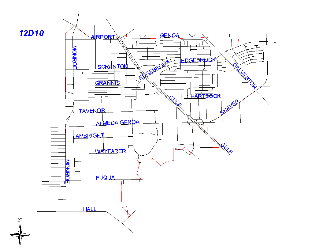
Click on map for larger, more detailed image
Beat Description and Boundary:
Beginning at the intersection of West Monroe Road and Airport Boulevard, the boundary goes easst to Gulf Freeway and continues east of the Gulf freeway on College to the city limits of Houston and South Houston. Airport Boulevard and College are not the responsiblility of 12D10's beat. Airport Boulevard is the responsiblityof 13D20 and College is the responsibility of 11D50. It turns south at the intersection of College and EAst Haven Boulevard and follws the city limits along East Haven Boulevard to Marleen. The boundary turns east and follows the city limits along Marleen to Pearlhall. It turns south and follows the city limits along Pearlhall to Edgebrook. It turns east and follows the city limits south along Shaver. The boundary continues to follow Shaver as Shaver winds east to the Gulf Fwy. It turns south east along the east service road of the Gulf Freeway. It turns southeast along the east service road ofthe Gulf Freeway to the intersection with Kingspoint. Therefore, the Gulf Freeway will be the responsibility of 12D10's. The boundary continues west along Kingspoint to Torrington. Kingspoint will be the responsiblity of 12D20's beat. It then turns northwest and follows the lot lines on the northeast side of Torrington. Torrington will be the responsiblity of 12D20's beat. It turns south and follows the lot lines on the west side of Alta Loma Way to a straight line from Goya to Fonville. Alta Loma Way is the responsiblity of 12D20's beat. The boundary continues southwest on Goya to Mango. It turns northwest and follows the lot lines on the northeast side of Mango until Mango turns straight west and Fonville continues on the north of Mango. The beat boundary takes in the addresses of Fonville, following the lot lines on the north of Fonville where it turns west to Stover. Mango and Fonville is the responsiblity of 12D20's beat. At Stover, it turn south and follows the Almeda Genoa Drainage Ditch on the west side of the Stover street lines. The boundary follows the Almeda Genoa Drainage Ditch to Fuqua. It turns south and follows the lot lines on the west side of Blackhawk to Kingspoint. It turns southwest and follows Kingspoint to Hall. Kingspoint is the responsiblity of 12D20's beat. It follows Hall west to Monroe Road. The boundary turns north on Monroe Road to West Monroe Road and continues north on West Monroe Road to the intersection with Airport Boulevard. Monroe Road and West Monroe Road are the responsiblity of 13D30 and 13D40.
Landmarks and Neighborhoods Within This Beat:
Almeda Mall, Southridge, Edgebrook, South Houston Gardens
ZIP Codes Within This Beat (see note below on ZIP codes and beats):
77017
77034
77061
77075
77089
77504
77587