
 > Police >
POLICE Department
Crime Statistics for 17E40's Beat
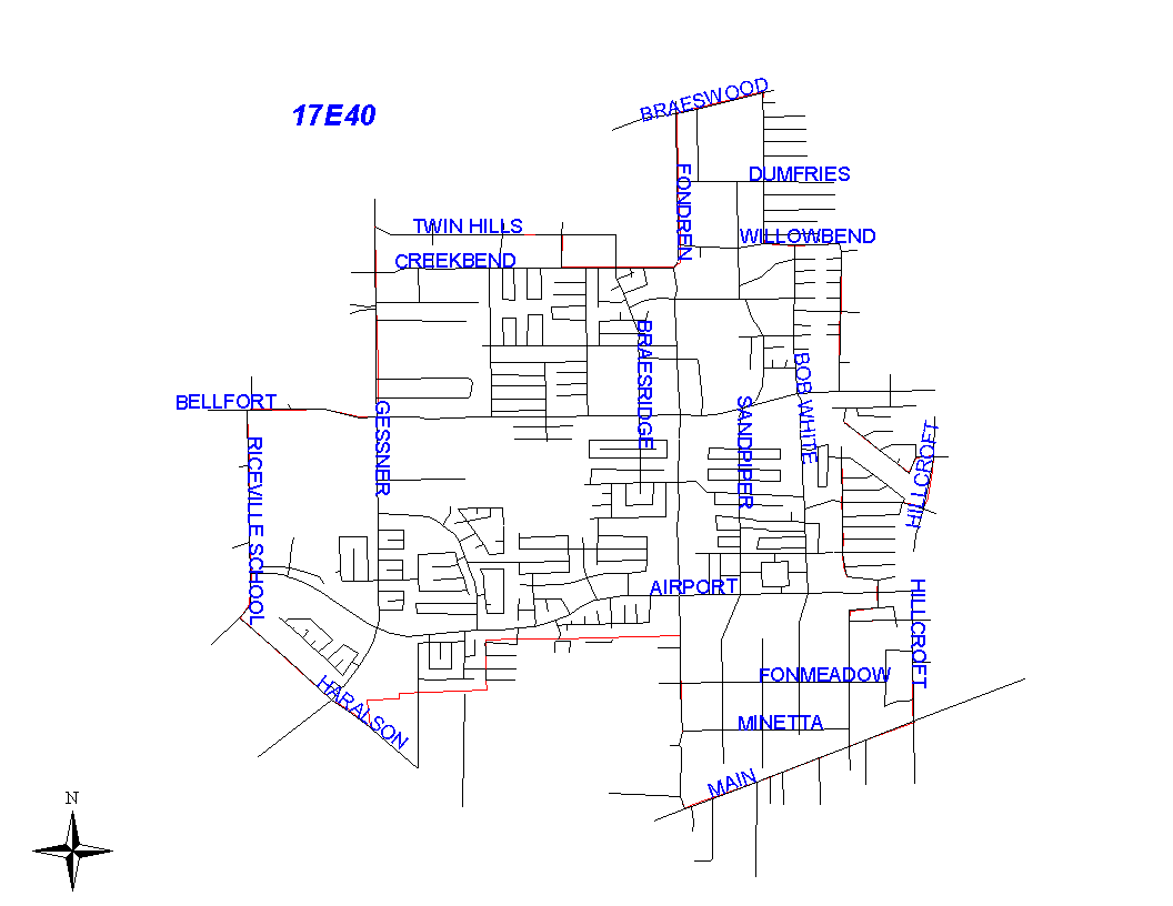
Click on map for larger, more detailed image
Beat Description and Boundary:
The boundary begins at the intersection of the South Gessner and Twin Hills and goes east along the south lot lines of Twin Hills to Valley Hills. It turns south along the east lot lines of Valley Hills to Creekbend. It continues east along Creekbend and goes along the north lot lines of Creekbend to Fondren. The boundary turns north along the east lot lines of Fondren and goes to Brays Bayou. It turns east along Brays Bayou and goes to Bob White. The boundary turns south along the west side of Bob White and goes to Willowbend. It turns east along the north lot lines of Willowbend and goes to Braewick. It turns south along the west lot lines of Braewick and goes to West Bellfort. It goes east along the south lot lines of West Bellfort to Kirkside. It turns south along the west lot lines of Kirkside and goes to Warm Springs. It turns west along the south lot lines of Warm Springs and goes to Braewick. It continues south along the west lot lines of Braewick to Beaudry. It turns southeast along the north lot lines of Beaudry to Dunlap. It turns north along the west lot lines of Dunlap to Burlinghall. It turns east along the north lot lines of Burlinghall to Hillcroft. It turns south along the west lot lines of Hillcroft to Ludington. It turns west along the south lot lines of Ludington to Lattimer. It turns northwest along the southwest lot lines of Lattimer and goes to Braewick. It continues south along the west lot lines of Braewick and goes to Ettrick. It goes east along the south lines of Ettrick to Kirkside. It goes south along the west lot lines of Kirkside to Fontenelle. It turns west along the north lot lines of Fontenelle and goes to Haviland. It turns south along the west lot lines of Haviland and goes to Densmore. It turns east along the south lot lines of Densmore and goes to Hillcroft. It turns south along the west lot lines of Hillcroft and goes to the SPRR railroad tracks just north of South Main. The beat boundary turns southwest along the SPRR railroad tracks and goes to the Houston city limits. It follows the city limits north along Fondren about to Secretariat. The beat boundary follows the city boundary as it turns west until it intersects with Riceville Road. The boundary turns north along Riceville Road and goes along the east lot lines to West Bellfort. It turns east along the south lot lines of West Bellfort and goes to South Gessner. It turns north along the east lot lines of Gessner and goes to the intersection with Twin Hills, which is where it begins.
Landmarks and Neighborhoods Within This Beat:
Creekbend, Southwood, Fondren Southwest
ZIP Codes Within This Beat (see note below on ZIP codes and beats):
77031
77035
77071
77074
77096