
 > Police >
POLICE Department
Crime Statistics for 6B30's Beat
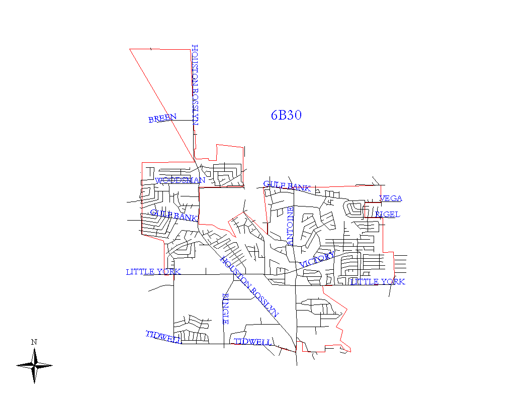
Click on map for larger, more detailed image
Beat Description and Boundary:
The boundary begins on West Little York between Langfield and Denny where the Houston City Limits go north. The boundary follows the city limits north to Williams, west on Williams to Hollister, north on Hollister to Log View, east on Log View to the city limit boundary just west of the White Oak Bayou and south to Jean. The beat boundary continues to follow the city limts east on Jean to North Houston Rosslyn Road, south on North Houston Rosslyn Road to White Oak Bayou, east and southeast along White Oak Bayou to the FWDCRIP Railroad. They continue northwest along the Railroad until the city limit boundary turns northeast to Alabonson. They turn southeast on Alabonson until the city limits turn north at Greenlawn. They continue north on Greenlawn to the city limits on the north side of West Gulf Bank where they turn east. The city limits turn north at Epps gully on the west side of Paradise Cemetary, but the beat boundary contues east along the Northwest Harris County MUD 8 line along the south side of the cemetery and along the south lot lines of Stallings Drive. The area between the lot lines of Stallings Drive and Gulf Bank is open space. There is no intersecting street before West Montgomery. The beat boundary, however, turns south at a point between Gloyna and Lonallen that would be intersected if Haynes street were extended straight north from Vega. The beat boundary follows this line south to Vega. It turns west on the south lot lines of Vega to Scenic green and turns south along the east lot lines of Scenic Green to Rigel. It turns east along the south lot lines of Rigel to Haynes, it turns south on Haynes for one block to Ferguson Way. Addresses on both sides of Haynes are the responsibility of 6B40's beat. The boundary continues south along the west lot lines of Lincoln Drive to Victory Drive. It turns east on Victory Drive to Dubois. Addresses on both sides of Victory are the responsiblity of 6B40. The boundary contiues south on the west side of Dubois to West Little York. It turns west on West Little York until it crosses the White Oak Bayou. West Little York is the responsibility of 6B30. The boundary turns south on the White Oak Bayou and folllows it south to the north lot lines of Droody in the Candlelight Subdivision Section 2. It turns west along the north lot lines of Droody to Ashoak. It turns south along the west lot lines of Ashoak to Bayou Vista. It turns west along the north lot lines of Bayou Vista to West Tidwell. It turns west on West Tidwell to Langfield. Tidwell is the responsibility of 6B30. The boundary turns north on Langfiel and goes to West Little York. Langfield is the responsibility of 6B30. The boundary turns west on the south lot lines of West Little York and goes to the intersection with the city limits north which is where it began.
Landmarks and Neighborhoods Within This Beat:
Woodland Trails, Oaks of Inwood, Bayou Bend, Cole Creek Manor, Inwood Forest
ZIP Codes Within This Beat (see note below on ZIP codes and beats):
77040
77064
77086
77088
77091
77092