
 > Police >
POLICE Department
Crime Statistics for 14D20's Beat
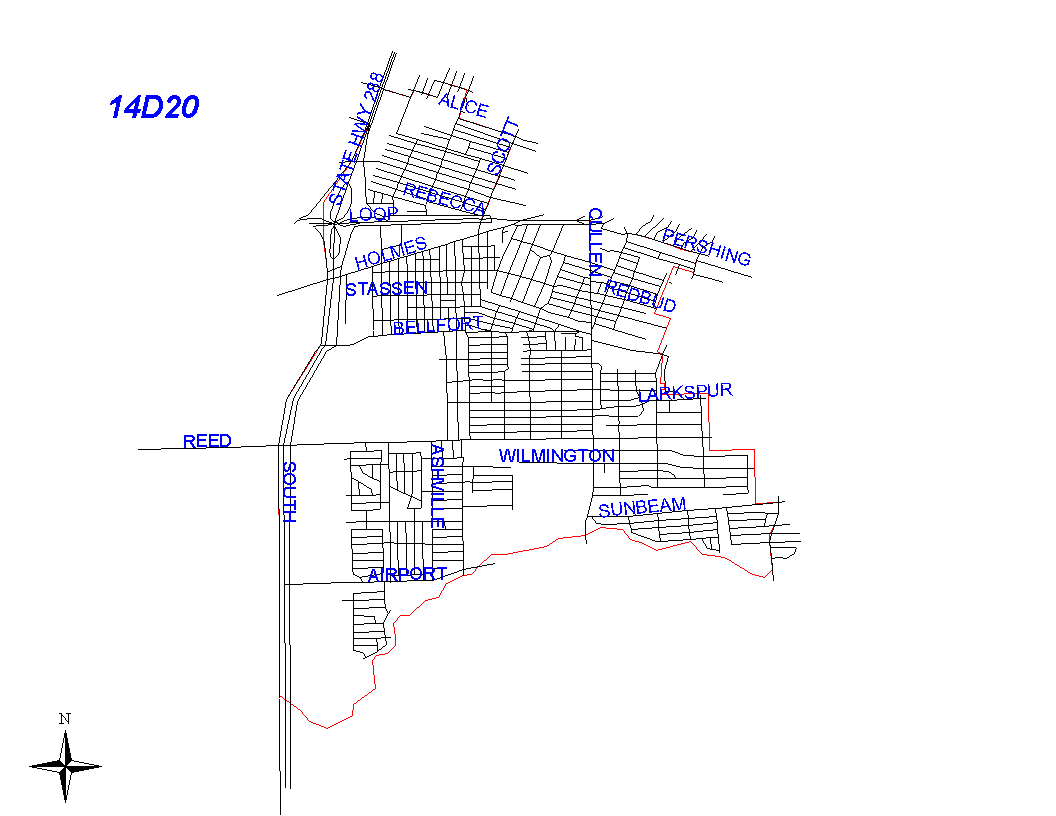
Click on map for larger, more detailed image
Beat Description and Boundary:
The boundary begins at the intersection of the South Freeway and Alice and goes east on Alice to Del Rio, north on Del Rio for one block to Idaho, east two blocks on Idaho to Lozier, north one block on Lozier to Ward, two blocks east on Ward to Winton, three blocks south on Winton to Southlawn, and east on Southlawn to Scott. All of these streets are in 14D10's beat. The boundary turns south on Scott to the South Loop. Scott is in 14D20's beat. The beat boundary follows the South Loop east to Bastian. It takes Bastian to Pershing, and Pershing east to the intersection of Pershing, Calhoun, and the South Park subdivision boundary. (See City of Houston Tax Maps, Page 229, 5454, D3-D4). On the south of Pershing and east of Calhoun is the South Park Subdivision. The beat boundary goes along the north boundary of South Park Subdivision, then along the east boundary of the South Park Subdivision at Jutland. A half block south of Vanfleet on Jutland, the South Park Subdivision boundary turns west. The beat boundary follows this subdivision boundary west. About a half block west of Darney, an alley turns south from the subdivision boundary and runs into the subdivision boundary between the Southland Acres and Smallwood Terrace Subdivisions. The beat boundary follows the alley to the subdivision boundary and continues along the subdivision boundary to Bellfort. About one-half block east on Bellfort is the intersection with Jutland. The next intersection on Bellfort is Panay. About halfway between Jutland and Panay, a subdivision boundary goes south. The beat boundary follows this subdivision. The subdivision boundary turns east along the lot lines just south of Westover Street. This line continues about one-half block west of St.Lo Street. The beat boundary follows this line for approximately five blocks east. The Inwood Terrace Subdivision boundary turns south between Noel and Rockford. It turns east between Hirondel and Carmen. The beat goundary follows this subdivision boundary south and east. The subdivision boundary turns south again about a half block east of Merle Street. The beat boundary follows this subdivision boundary south. Just before sunbeam, it follows the lot lines along Bayfield to Martin Luther King Boulevard. The beat boundary follows Martin Luther King Blvd. south to Sims Bayou. Martin Luther King blvd. is the responsibility of 14D30's beat. It follows Sims Bayou west to the South Freeway. The boundary then follows the South Freeway north to the intersection with Alice where it begins. The South Freeway is the responsibility of 14D20.
Landmarks and Neighborhoods Within This Beat:
Blueridge, Sunnyside, Brook Haven, Bayou Estates
ZIP Codes Within This Beat (see note below on ZIP codes and beats):
77021
77033
77047
77048
77051
77054