Houston Heights West, East and South
Boundaries
The Houston Heights was designated as a Multiple Resource Area (MRA) in 1983 by the National Park Service. Houston Heights was designated as a MRA because it was at one time an independent municipality of less than 50,000 inhabitants (1896-1918), and the area also contains a large number of buildings that have been individually listed in the National Register of Historic Places. During the MRA designation, it was recommended by the National Park Service, as well as by the Texas Historical Commission, that multiple historic districts should be established within the boundaries of Houston Heights. Generally the approach for an historic district designation is to designate the entire neighborhood as it was originally platted. Since Houston Heights was originally its own planned town, it retained its own separate character and diversity when it was annexed by Houston. Thus the approach for the creation of several historic districts within Houston Heights tries to uniquely identify and denote that diversity of development found in Houston Heights and recognize distinct areas.
Houston Heights currently contains three City of Houston designated Historic Districts. They are named for their location within the Heights: West, East and South. The boundaries of the three Houston Heights Historic Districts mark areas that are still largely intact. Many changes in Houston Heights have taken place along Yale Street, East and West 11th Street, East 19th Street and East 20th Street, and the frontage road of Interstate 10 (just south of 4th Street). In those areas, many historic buildings have been demolished to make way for commercial development. Also many historic buildings have been demolished west of Ashland Street. The neighborhoods east of Oxford Street were not part of the original Houston Heights plats; the block sizes and shapes are varied, and the lots are oriented north and south. The original Heights commercial district was located north of West 16th Street and west of Yale Street, and the lots there are configured differently.
In the Houston Heights historic districts, named streets run north and south. East-west streets are numbered, beginning with 4th St just north of I-10 and continuing to 20th St on the north side of Heights East. Sixth Street is also known as White Oak Boulevard. Numbered streets are named ‘West’ on the west side of Heights Blvd are ‘East’ on the east side of Heights Blvd.
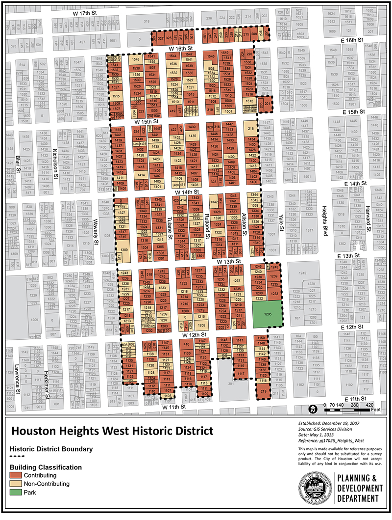
Houston Heights West
The Houston Heights Historic District West is roughly bounded by West 16th Street to the north, Yale Street to the east, West 11th Street to the south, and Ashland Street to the west. It includes 13 full blocks and 14 partial blocks of mostly residential buildings. Smaller lots 33 feet in width were platted along Ashland, Rutland and Tulane Streets, although two or more lots were often combined to make a larger lot.
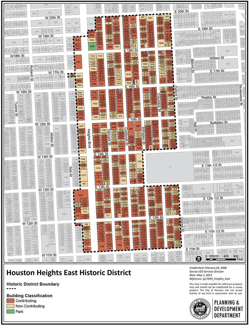
Houston Heights East
The Houston Heights Historic District East is roughly bounded by Heights Boulevard to the west, Oxford Street to the east, West 20th street to the north, and West 11th Street to the south. The 1200 block of Yale and two lots at Yale and 17th are also included. The district contains 34 full blocks and nine partial blocks of residential, commercial, and institutional buildings.
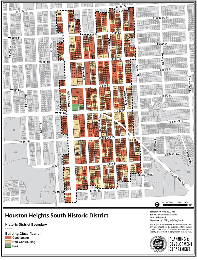
Houston Heights South
The Houston Heights Historic District South is roughly bounded by Heights Boulevard to the west, Oxford Street to the east, West 11th street to the north, and West 4th Street to the south. The district contains 26 full blocks and 16 partial blocks of residential, commercial, and institutional buildings. It is directly south of, and contiguous to, the Houston Height Historic District East.