
 > Police >
POLICE Department
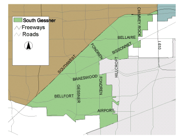
Crime Statistics for South Gessner Patrol Division
Estimated Population: 154,044
Approximate Square Miles: 16.0
17E10
Approximate street boundaries:
North: Hwy 59 Southwest Fwy
East: Bellaire City Limits
South: Pine to Bellaire
West: Hillcroft to Hwy 59
Landmarks/Neighborhoods: Southwest Memorial Hospital, Burnett
Bayland Park, Westmoreland
Click here for a detailed text description
of the boundaries of this beat.
Click here for a detailed map of this beat.
17E20
Approximate street boundaries:
North: Hwy 59 to Bellaire
East: Hillcroft to Fondren
South: Beechnut to Creekbend
West: S. Gessner
Landmarks/Neighborhoods: Houston Baptist University area, Maplewood
West
Click here for a detailed text description
of the boundaries of this beat.
Click here for a detailed map of this beat.
17E30
Approximate street boundaries:
North: Hwy 59
East: S. Gessner
South: W. Bellfort to W. Airport
West: Hwy 59
Landmarks/Neighborhoods: Braeburn Valley West, Glenshire
Click here for a detailed text description
of the boundaries of this beat.
Click here for a detailed map of this beat.
17E40
Approximate street boundaries:
North: S. Braeswood
East: Hillcroft
South: South Main
West: S. Gessner
Landmarks/Neighborhoods: Creekbend, Southwood, Fondren Southwest
Click here for a detailed text description
of the boundaries of this beat.
Click here for a detailed map of this beat.