
 > Police >
POLICE Department
Crime Statistics for Eastside Patrol Division
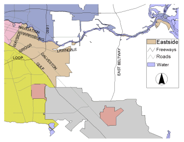
Estimated Population: 91,272
Approximate Square Miles: 20.4
11H10
Approximate street boundaries:
North: HB&T RR Track
East: Houston Ship Channel
South: Griggs
West: I-45
Landmarks/Neighborhoods: Mason Park, Forest Hill, Sunnyland, Central
Park
Click here for a detailed text description
of the boundaries of this beat.
Click here for a detailed map of this beat.
11H20
Approximate street boundaries:
North: Griggs to Houston Ship Channel
East: Houston Ship Channel
South: LaPorte Fwy to 610 South Loop East
West: I-45
Landmarks/Neighborhoods: Harrisburg, Manchester, Pecan Park
Click here for a detailed text description
of the boundaries of this beat.
Click here for a detailed map of this beat.
11H30
Approximate street boundaries:
North: 610 South Loop East
East: Sims Bayou
South: Berry Creek
West: I-45
Landmarks/Neighborhoods: Meadow Brook, Park Place
Click here for a detailed text description
of the boundaries of this beat.
Click here for a detailed map of this beat.
11H40
Approximate street boundaries:
North: Sims Bayou
East: Scarborough
South: Allendale
West: Sims Bayou
Landmarks/Neighborhoods: Allendale, Oak Meadows
Click here for a detailed text description
of the boundaries of this beat.
Click here for a detailed map of this beat.
11H50
Approximate street boundaries:
North: Berry Creek to Allendale
East: Allen Genoa to West of Canniff
South: College
West: I-45
Landmarks/Neighborhoods: Meadow Creek, Ferndale Addition, Glenbrook
Industrial
Click here for a detailed text description
of the boundaries of this beat.
Click here for a detailed map of this beat.