
 > Police >
POLICE Department
Crime Statistics for Midwest Patrol Division
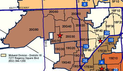
Estimated Population: 148,232
Approximate Square Miles: 18.67
18F10
Approximate street boundaries:
North: I-10 Katy Fwy
East: 610 West Loop North
South: Buffalo Bayou
West: Hunters Creek City Limits
Landmarks/Neighborhoods: Saddlebrook, Bayou Woods, Sherwood Forest
Click here for a detailed text description of the boundaries of this beat.
Click here for a detailed map of this beat.
18F20
Approximate street boundaries:
North: Buffalo Bayou
East: 610 West Loop North
South: Hwy 59
West: Chimney Rock
Landmarks/Neighborhoods: The Galleria, Tanglewood, Riverway, Post
Oak
Click here for a detailed text description
of the boundaries of this beat.
Click here for a detailed map of this beat.
18F30
Approximate street boundaries:
North: Buffalo Bayou
East: Chimney Rock
South: Hwy 59
West: Hillcroft / Voss
Landmarks/Neighborhoods: The Richmond Strip, Briargrove, Post
Oak Estates, Westhaven
Click here for a detailed text description
of the boundaries of this beat.
Click here for a detailed map of this beat.
18F40
Approximate street boundaries:
North: Buffalo Bayou
East: Hillcroft / Voss
South: Windswept to Richmond to Westheimer
West: S. Gessner
Landmarks/Neighborhoods: Rosewood General Hospital, Woodlake,
Briarmeadow
Click here for a detailed text description
of the boundaries of this beat.
Click here for a detailed map of this beat.
18F50
Approximate street boundaries:
North: Westheimer
East: Hillcroft
South: Hwy 59
West: Fondren to S. Gessner
Landmarks/Neighborhoods: Tanglewild, Sharpstown Mall, Regency
Square
Click here for a detailed text description
of the boundaries of this beat.
Click here for a detailed map of this beat.
18F60
Approximate street boundaries:
North: Westpark
East: Fondren
South: Hwy 59
West: Brays Bayou
Landmarks/Neighborhoods: Sharpstown Country Club, Southway Center
Click here for a detailed text description
of the boundaries of this beat.
Click here for a detailed map of this beat.