
 > Police >
POLICE Department
Crime Statistics for Central Patrol Division
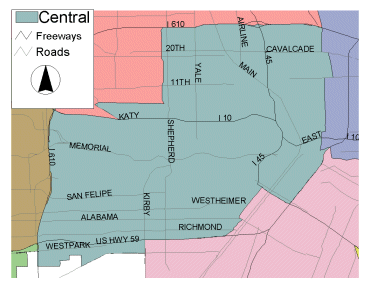
Estimated Population: 203,623
Approximate Square Miles: 29.5
1A10 (Downtown District,
Special Operations Division)
Approximate street boundaries:
North: I-10
East: Hwy 59
South: I-45
West: I-45
Landmarks/Neighborhoods: Houston's Downtown Central Business District,
including many commercial, residential and retail landmarks such
as Bayou Place, the Theatre District, the Rice Lofts, and Minute
Maid Park.
Click here for a detailed text description
of the boundaries of this beat.
Click here for a detailed map of this beat.
1A20
Approximate street boundaries:
North: Memorial Drive (Buffalo Bayou)
East: I-45 to Spur 527
West: Montrose to Waugh to Shepherd
Landmarks/Neighborhoods: Fourth Ward, Avondale, Westmoreland
Click here for a detailed text description
of the boundaries of this beat.
Click here for a detailed map of this beat.
1A30
Approximate street boundaries:
North: West Gray
East: Waugh to Montrose
South: Hwy 59
West: Buffalo Speedway to S. Shepherd
Landmarks/Neighborhoods: Cherryhurst, Mandell Place, Montrose
Click here for a detailed text description
of the boundaries of this beat.
Click here for a detailed map of this beat.
1A40
Approximate street boundaries:
North: Buffalo Bayou
East: S. Shepherd
South: Westheimer
West: St. Regis PL
Landmarks/Neighborhoods: Tall Timbers, Royden Oaks, River Oaks,
Avalon Place, Oak Estates, River Oaks Country Club
Click here for a detailed text description
of the boundaries of this beat.
Click here for a detailed map of this beat.
1A50
Approximate street boundaries:
North: Buffalo Bayou to Westheimer to Southwest Fwy
East: St. Regis Place to Buffalo Speedway to Kirby
South: Bissonnet
West: 610 West Loop
Landmarks/Neighborhoods: Post Oak Park, Afton Oaks, Highland Village,
Weslayan, Greenway Plaza, The Compaq Center, Twelve Oaks Hospital
Click here for a detailed text description
of the boundaries of this beat.
Click here for a detailed map of this beat.
2A10
Approximate street boundaries:
North: Cavalcade to 610
East: Elysian
South: I-10
West: I-45
Landmarks/Neighborhoods: Irvington, Ryon
Click here for a detailed text description
of the boundaries of this beat.
Click here for a detailed map of this beat.
2A20
Approximate street boundaries:
North: 610
East: Robertson to I-45
South: Cavalcade
West: North Main
Landmarks/Neighborhoods: Sunset Heights, Brooksmith, Stude
Click here for a detailed text description
of the boundaries of this beat.
Click here for a detailed map of this beat.
2A30
Approximate street boundaries:
North: 610 North Loop
East: North Main
South: I-10
West: North Durham
Landmarks/Neighborhoods: Houston Heights, Norhill, Studemont
Click here for a detailed text description
of the boundaries of this beat.
Click here for a detailed map of this beat.
2A40
Approximate street boundaries:
North: I-10
East: I-45
South: Buffalo Bayou (Between Memorial Drive and Allen Parkway)
West: Montrose
Landmarks/Neighborhoods: Old Sixth Ward, First Ward
Click here for a detailed text description
of the boundaries of this beat.
Click here for a detailed map of this beat.
2A50
Approximate street boundaries:
North: I-10
East: Montrose
South: Buffalo Bayou
West: 610
Landmarks/Neighborhoods: Memorial Park, West End, Ashbury, Cottage
Grove
Click here for a detailed text description
of the boundaries of this beat.
Click here for a detailed map of this beat.
Crime stats for this beat: click
here.
*** NOTE: On January 1, 2007, 3B20's Beat Became 2A60's Beat and is now patrolled by Central. ***
Approximate street boundaries:
North: 610 North Loop West
East: N.Durham
South: 1-10
West: 610 West Loop North
Landmarks/Neighborhoods: Westport, Holly Park, Lazy Brook, Citadel, Shady Acres, Timbergrove
Click here for a detailed text description of the boundaries of this beat.
Click here for a detailed map of this beat.