
 > Police >
POLICE Department
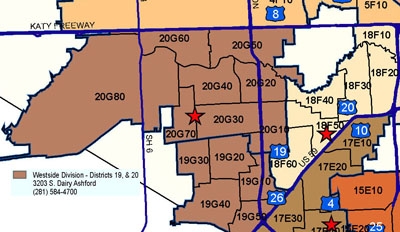
Crime Statistics for Westside Patrol Division
Estimated Population: 340,857
Approximate Square Miles: 67.6
19G10
Approximate street boundaries:
North: Bellaire
East: Corporate
South: Bissonnet
West: Wilcrest
Landmarks/Neighborhoods: Concourse South, Westwood Mall
Click here for a detailed text description
of the boundaries of this beat.
Click here for a detailed map of this beat.
19G20
Approximate street boundaries:
North: Harwin
East: Wilcrest
South: Beechnut
West: Cook
Landmarks/Neighborhoods: Catalina Square, Bellaire West, Imperial
Point
Click here for a detailed text description
of the boundaries of this beat.
Click here for a detailed map of this beat.
19G30
Approximate street boundaries:
North: Alief Clodine
East: Cook
South: Wellington Park
West: East of Synott
Landmarks/Neighborhoods: Rodeo Square, Wildflower Green, Braewood
Glen
Click here for a detailed text description
of the boundaries of this beat.
Click here for a detailed map of this beat.
19G40
Approximate street boundaries:
North: Beechnut
East: Boone
South: W. Bellfort
West: Synott
Landmarks/Neighborhoods: Huntington Village, Wellington Park,
Leawood, Keegans Glen
Click here for a detailed text description of the boundaries of this beat.
Click here for a detailed map of this beat.
19G50
Approximate street boundaries:
North: Bissonnet
East: Hwy 59
South: City Limits
West: S. Kirkwood
Landmarks/Neighborhoods: Forum Park, Stancliff, Southwest Park
Click here for a detailed text description of the boundaries of this beat.
Click here for a detailed map of this beat.
20G10
Approximate street boundaries:
North: Westheimer
East: S. Gessner
South: Bellaire
West: Wilcrest to West Sam Houston Pkwy
Landmarks/Neighborhoods: Westchase, Woodchase Village, Point West
Click here for a detailed text description
of the boundaries of this beat.
Click here for a detailed map of this beat.
20G20
Approximate street boundaries:
North: Buffalo Bayou
East: S. Gessner
South: Westheimer
West: Wilcrest
Landmarks/Neighborhoods: Lakeside Estates, City West Place, Rivercrest,
Briargrove Park
Click here for a detailed text description
of the boundaries of this beat.
Click here for a detailed map of this beat.
20G30
Approximate street boundaries:
North: Westheimer
East: West Sam Houston Pkwy
South: Harwin
West: Dairy Ashford
Landmarks/Neighborhoods: West Houston Medical Center, Andrau Airport,
Westchase, Westchase Mall
Click here for a detailed text description
of the boundaries of this beat.
Click here for a detailed map of this beat.
20G40
Approximate street boundaries:
North: Buffalo Bayou
East: Wilcrest
South: Westheimer
West: Dairy Ashford
Landmarks/Neighborhoods: Lakeview Forest, Lakeside Place, Ashford
Village, Southlake
Click here for a detailed text description
of the boundaries of this beat.
Click here for a detailed map of this beat.
20G50
Approximate street boundaries:
North: I-10 Katy Fwy
East: Hedwig and Bunker Hill City Limits
South: Buffalo Bayou
West: Rancho Bauer to Carlingford
Landmarks/Neighborhoods: Nottingham, Yorkshire, Wilchester, Town
and Country Village, Memorial City Shopping Center
Click here for a detailed text description
of the boundaries of this beat.
Click here for a detailed map of this beat.
20G60
Approximate street boundaries:
North: I-10 Katy Fwy
East: Carlingford to Rancho Bauer
South: Buffalo Bayou
West: West of Hwy 6
Landmarks/Neighborhoods: Barkers Landing, Fleetwood, Thornwood,
Darrel Tully Stadium
Click here for a detailed text description
of the boundaries of this beat.
Click here for a detailed map of this beat.
20G70
Approximate street boundaries:
North: Westella
East: Dairy Ashford
South: Alief Clodine
West: Synott
Landmarks/Neighborhoods: Westpark Village, Ashford Point
Click here for a detailed text description
of the boundaries of this beat.
Click here for a detailed map of this beat.
20G80
Approximate street boundaries:
North: Barker Dam
East: Eldridge Pkwy
South: Westheimer
West: City Limits
Landmarks/Neighborhoods: City Limits
Click here for a detailed text description
of the boundaries of this beat.
Click here for a detailed map of this beat.