
 > Police >
POLICE Department
Neighborhood (Police Beat) Crime Statistics
The
information contained in these reports, Uniform Crime Report data, is a monthly breakdown
of Part I crimes for which HPD wrote police reports. The
data is broken down by police districts and
beats and shows reports of the following types
of crimes:
- Murder
- Rape
- Robbery
- Aggravated assault
- Burglary
- Theft
- Auto theft
police beat - geographic area of the city broken down for patrol and statistical purposes
uniform crime report - monthly release of data to the FBI. The monthly report is released approximately 15 - 20 days from the last day of the previous month.
premise codes - identify type of location where crime occurred (apartment
complex, parking lot, etc) click here for complete list
In order to obtain the information, you will need to determine which area of the city you wish to research. Here are the steps you need to follow:
- Step One
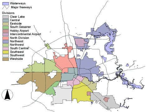
Choose the area of Houston you wish to research from the clickable, graphic map below or from the list. - Step Two
Once you have chosen a general area, you will be presented with a district map and you will need to choose a specific beat. Each beat is described in detail, with general street boundaries and landmarks / neighborhoods, ZIP codes that are within that beat, a detailed map, and a text description of the boundaries of the beat. - Step Three
After choosing the month to view, you will be presented with a table containing the stats for the above crimes for which we wrote police reports in the selected beat and month. The table will show the type of offense, date and time, district and beat, premise code of the location, block numbers and street name. For privacy reasons, exact addresses are not shown, only the hundred blocks. PLEASE NOTE: In accordance with the national shift in crime data collection and reporting methods, the Houston Police Department is currently transitioning from UCR to NIBRS ahead of the FBI’s 2021 deadline. The publication of summary crime data and departmental reports has been delayed due to this transition. Crime data for June 2018 and the months following will be provided as soon as the department is granted state certification under the NIBRS data collection method.
or
Select an area from the list:
Downtown Central
North
Northeast Kingwood
Eastside
South Central
Clear Lake
Southeast
Fondren
Midwest
Southwest
Westside
Northwest
Intercontinental Airport
Hobby Airport
HPD Beat Map (pdf file): Printable document showing HPD beats and districts and locations of HPD stations and storefronts.
Notes:
- The Houston Police Department does not recommend raw data comparisons be made between police beats. This web site does not provide a comparative analysis of the various beats.
- If you plan to print out the crime statistic tables, for best results, choose the "landscape" orientation from the properties menu in your printer dialogue box.
- ZIP code boundaries and police beat boundaries do not correspond. ZIP code boundaries may overlap beat boundaries and there may be several beats within several ZIP codes and vice versa. ZIP codes are provided only as a reference.
- PLEASE NOTE: In accordance with the national shift in crime data collection and reporting methods, the Houston Police Department is currently transitioning from UCR to NIBRS ahead of the FBI’s 2021 deadline. The publication of summary crime data and departmental reports has been delayed due to this transition. Crime data for June 2018 and the months following will be provided as soon as the department is granted state certification under the NIBRS data collection method.